Topsmelt
-
Scientific NameAtherinops affinis
-
NativeNative Species
-
Identification
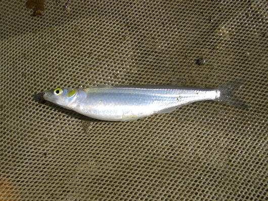
 Topsmelt, captured from the Santa Clara River Estuary, Ventura County, CA on 28 March 2004. Photo by Steve Howard.
- Small and slim, up to 37 cm TL
- Fattened dorsally, lateral line absent
- Two dorsal fins separated
- Small oblique mouth: one row of tiny forked teeth per jaw
- Bright green back, silver to pale sides, silvery underside
- Juveniles: translucent white with midline stripe, 3 pigmented scale rows on back-scattered on caudal peduncle
- Fin spines/rays: 1st dorsal 5-9 spines, 2nd dorsal 1 spine/8-14 rays, anal 1 spine/19-25 rays, pectoral 13 rays
- Lateral line scales: line absent, 63-65 lateral scales
-
Life History
Topsmelt are primarily marine fish, though they are commonly found in bays, estuaries, and the mouths of coastal streams. They are capable of living in water with salinities ranging from fresh to pure sea water and in temperatures ranging from 5 to 29°C. Topsmelt are also capable of surviving exposures to extreme salinities up to 80 ppt. They are rarely found in freshwater and fish occupying fresh or brackish waters are usually young-of-year. Topsmelt are benthically oriented and usually feed by grazing the bottom of the water column. These omnivores may feed on diatoms, algae, detritus, chironomid midge larvae, and amphipods. Juvenile topsmelt are more likely to be found in freshwater and are less benthically focused. They have been found to consume various kinds of zooplankton. As juvenile fish age and develop they begin moving farther down into the estuary. Topsmelt spawn from March through October with optimal spawning waters having a salinity around 30 ppt and a temperature range of 13-27°C. Larvae move into deeper water when they hatch and may move up the estuary.
-
Links to Other ResearchN / A
-
Watershed
-
Alisal-Elkhorn Sloughs Watershed
-
Aliso-San Onofre Watershed
-
Big-Navarro-Garcia Watershed
-
Bodega Bay Watershed
-
Calleguas Watershed
-
Carmel Watershed
-
Chetco Watershed
-
Cottonwood Tijuana Watershed
-
Coyote Watershed
-
Gualala-Salmon Watershed
-
Los Angeles Watershed
-
Lower Eel Watershed
-
Lower Klamath Watershed
-
Lower Sacramento Watershed
-
Mad-Redwood Watershed
-
Mattole Watershed
-
Newport Bay Watershed
-
Pajaro Watershed
-
Russian Watershed
-
Salinas Watershed
-
Salmon Watershed
-
San Antonio Watershed
-
San Diego Watershed
-
San Francisco Bay Watershed
-
San Francisco Coastal South Watershed
-
San Gabriel Watershed
-
San Joaquin Delta Watershed
-
San Lorenzo-Soquel Watershed
-
San Luis Rey-Escondido Watershed
-
San Pablo Bay Watershed
-
Santa Ana Watershed
-
Santa Barbara Coastal Watershed
-
Santa Clara Watershed
-
Santa Margarita Watershed
-
Santa Maria Watershed
-
Santa Monica Bay Watershed
-
Santa Ynez Watershed
-
Seal Beach Watershed
-
Smith Watershed
-
Suisun Bay Watershed
-
Tomales-Drake Bays Watershed
-
Ventura Watershed
-
Please note, watersheds are at the USGS 8-digit Hydrologic Unit Code (HUC) scale, so they often include a lot of sub-watersheds. If a species occurs in any sub-watershed within the HUC, the species appears within the HUC. Link to an EPA page that shows HUCs.
