Prickly Sculpin
-
Scientific NameCottus asper
-
NativeNative Species
-
Identification
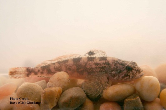
 Prickly sculpin, approximately 10 cm (4”) long. Location: Suisun Marsh, California. Date: 8/6/2007.
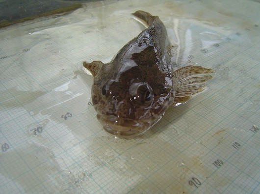
 Prickly sculpin (anterior view), captured in rotary screw trap on the Sacramento River at Knight's Landing on 2/26/2009. Photo by Dan Worth, California Department of Fish and Game.
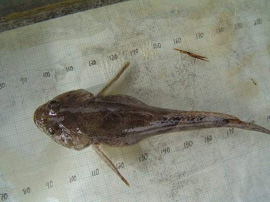
 Prickly sculpin (dorsal view), captured in rotary screw trap on the Sacramento River at Knight's Landing on 2/26/2009. Photo by Dan Worth, California Department of Fish and Game.
- Maximum size in California is about 20 cm SL
- Long anal fin (3 X longer than caudal peduncle)
- Long dorsal fins connected at base
- Palatine teeth usually visible, single chin pore (sometimes 2), 2-3 pre-opercular spines, 28-43 lateral line pores
- Mottled reddish brown to dark brown coloring, 4-5 dark saddles, white to yellow underside
- Fins often barred, 1st dorsal fin may have dark spot on posterior/tail side
- Males have long v-shaped genital papilla
- During breeding both sexes have dark coloring and orange leading edge on 1st dorsal fin
- Fin rays/spines: anal 16-19 rays, 1st dorsal 7-10 soft spines, 2nd dorsal 19-23 rays, pectoral 15-18 rays
- Pelvic fin "elements": 4 (1 spine, 4 rays, but the spine is fused with the 1st ray)
-
Life History
The prickly sculpin is adaptable to environments ranging from fresh to saltwater, and from small cool stream to large warm rivers and lakes. The prickly sculpin has a variety of forms as some are coastal, others live in the valley, and some are limited to Clear Lake proper. The coastal forms rarely live in a stream without an estuary and rarely go farther than 50 km upstream though they have been found present over 120 km upstream, often sharing habitat with the coastrange sculpin. In the Central Valley of California these fish inhabit low elevation waters. The limitation to the spread of these fish seems to be water quality, as the prickly sculpin is not found in highly polluted waters. In streams these fish use a variety of habitats though good cover or overhanging vegetation is a common thread. The prickly sculpin spends most of the day sedentarily hiding and they then becomes active in feeding and movement at night. When prickly sculpins reach sexual maturity after 2, 3, or 4 years they move to a suitable place in freshwater to spawn and hide the eggs under loose rock substrate. Most spawning occurs between February and June. The male will guard the fertilized eggs until they hatch. When the larvae emerge they are quickly washed downstream to an estuary or deep slow pool. In lakes and in estuaries the larvae become pelagic. As the larvae develop into juvenile fish they begin to move to area of prosperous feeding, often moving upstream a considerable distance. In many cases the movement of fish, and especially young prickly sculpin, is limited by man-made barriers or diversions. In lakes, juvenile prickly sculpin forage around the lake shores and then gradually move into deeper water as they grow.
Feeding patterns in the prickly sculpin vary depending upon geographical location and/or by size. For example in Clear Lake these fish may feed more consistently throughout the day. Both adults an juveniles eating midges and amphipods. While in coastal streams the food source includes benthic invertebrates, aquatic insects, and mollusks. Adult sculpins may supplement their diet with small fish and frogs.
-
Links to Other ResearchN / A
-
Watershed
-
Alisal-Elkhorn Sloughs Watershed
-
Big-Navarro-Garcia Watershed
-
Bodega Bay Watershed
-
Carmel Watershed
-
Central Coastal Watershed
-
Chetco Watershed
-
Cottonwood Headwaters Watershed
-
Coyote Watershed
-
Gualala-Salmon Watershed
-
Lower American Watershed
-
Lower Butte
-
Lower Cache Watershed
-
Lower Calaveras-Mormon Slough Watershed
-
Lower Cosumnes-Lower Mokelumne Watershed
-
Lower Cottonwood Watershed
-
Lower Eel Watershed
-
Lower Feather Watershed
-
Lower Klamath Watershed
-
Lower Sacramento Watershed
-
Mad-Redwood Watershed
-
Mattole Watershed
-
Middle San Joaquin-Lower Chowchilla Watershed
-
Middle San Joaquin-Lower Merced-Lower Stanislaus Watershed
-
Mill Watershed
-
Newport Bay Watershed
-
Pajaro Watershed
-
Panoche-San Luis Reservoir Watershed
-
Russian Watershed
-
Sacramento-Lower Cow-Lower Clear Watershed
-
Sacramento-Lower Thomes Watershed
-
Sacramento-Stone Corral Watershed
-
Sacramento-Upper Clear Watershed
-
Salinas Watershed
-
Salmon Watershed
-
San Antonio Watershed
-
San Francisco Bay Watershed
-
San Francisco Coastal South Watershed
-
San Gabriel Watershed
-
San Joaquin Delta Watershed
-
San Lorenzo-Soquel Watershed
-
San Pablo Bay Watershed
-
Santa Ana Watershed
-
Santa Barbara Coastal Watershed
-
Santa Clara Watershed
-
Santa Maria Watershed
-
Santa Ynez Watershed
-
Seal Beach Watershed
-
Smith Watershed
-
South Fork Eel Watershed
-
South Fork Trinity Watershed
-
Suisun Bay Watershed
-
Tomales-Drake Bays Watershed
-
Trinity Watershed
-
Tulare-Buena Vista Lakes Watershed
-
Upper Cache Watershed
-
Upper Calaveras Watershed
-
Upper Chowchilla-Upper Fresno Watershed
-
Upper Cosumnes Watershed
-
Upper Cow-Battle Watershed
-
Upper Dry Watershed
-
Upper Kaweah Watershed
-
Upper King Watershed
-
Upper Merced Watershed
-
Upper Mokelumne Watershed
-
Upper Putah Watershed
-
Upper San Joaquin Watershed
-
Upper Stanislaus Watershed
-
Upper Tuolumne Watershed
-
Ventura Watershed
-
Please note, watersheds are at the USGS 8-digit Hydrologic Unit Code (HUC) scale, so they often include a lot of sub-watersheds. If a species occurs in any sub-watershed within the HUC, the species appears within the HUC. Link to an EPA page that shows HUCs.


